Earthwork & site-work takeoff and estimating
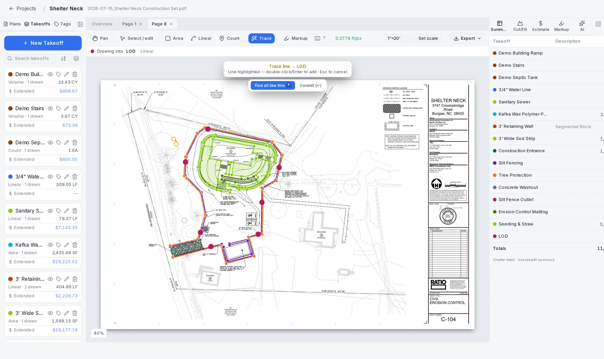
Click the silt fence.
It traces the whole run.
Auto-trace follows the linework for you, so a sheet full of silt fence, curb, pipe and contours turns into measured takeoffs in minutes. Then figure your cut and fill and hand the GC a branded bid. All in one tool.
$149.99/mo or $1,200/yr. No annual contract. Cancel anytime.

Built and used every day at Carolina EarthWerx. A real seven-figure site-work company.
- Excavation
- ·Grading
- ·Utilities
- ·Storm & drainage
- ·Concrete
- ·Asphalt & paving
- ·Erosion control
- ·Landscaping
Plans in, bid out
The whole takeoff, in one tool
No jumping between a PDF marker, a spreadsheet and a dirt program. Upload the set and go straight through to the bid.
- Step 1
Upload the plans
Drop in the PDF set. Big multi-page jobs stream page by page, so a 40 MB set opens fast.
- Step 2
Set the scale
Type the scale off the sheet (1"=50', 1:50, or just 50) or drag the graphic bar. Every sheet, its own scale.
- Step 3
Measure with auto-trace
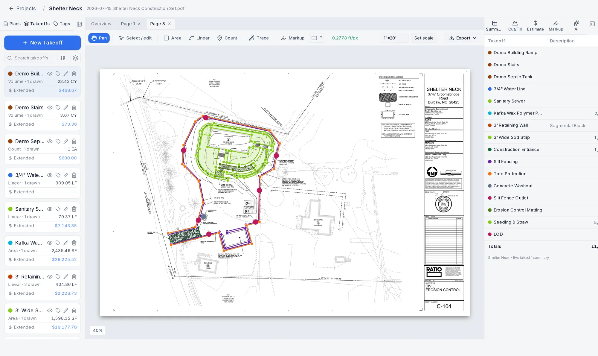
Click a line and it follows the whole run. Area, linear, count, arcs. Auto-trace does the clicking for you.
- Step 4
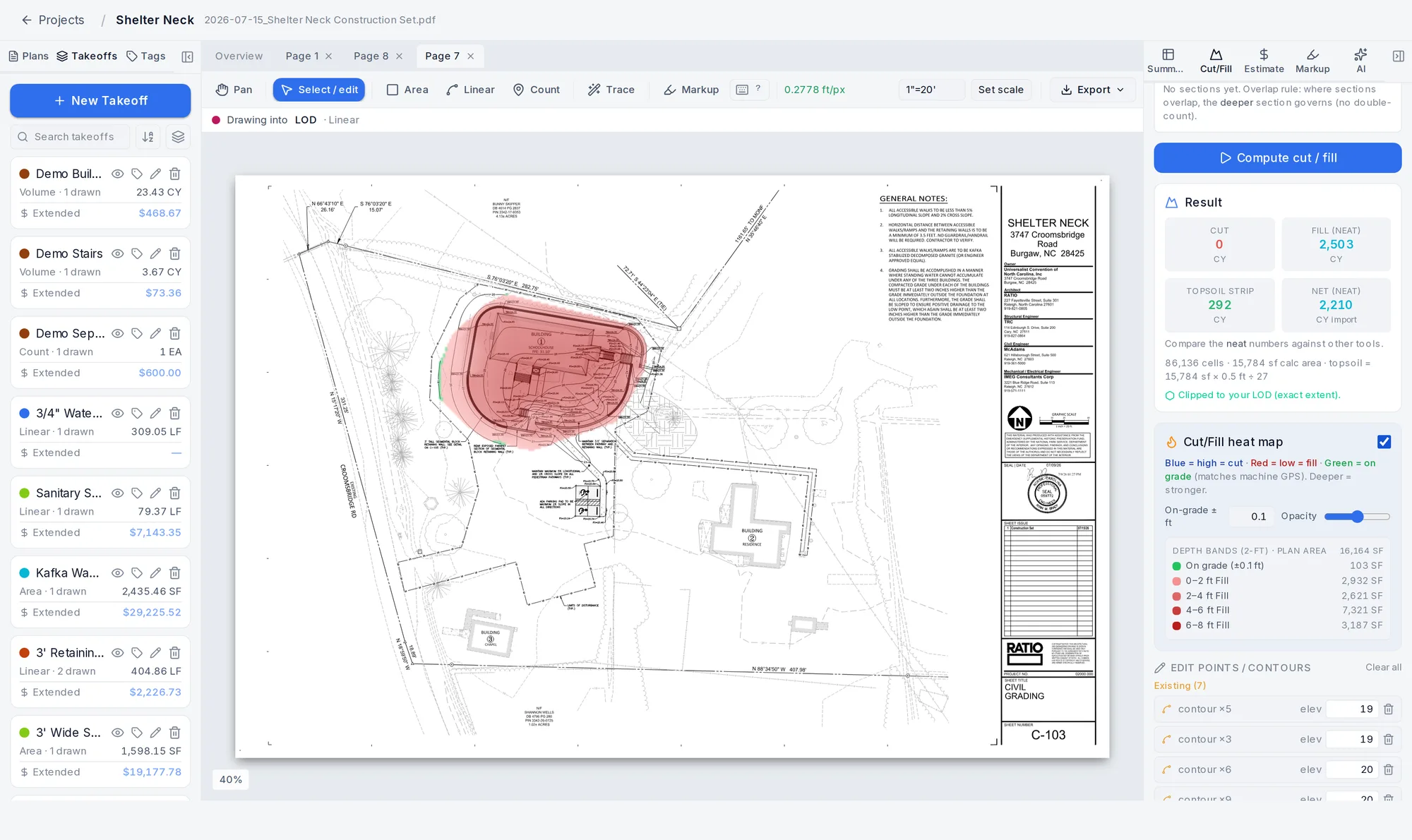
Figure your dirt
Existing and proposed surfaces, cut, fill and net yards inside your limits of disturbance. Know it before you bid.
- Step 5
Price it
Price the takeoff off your own Cost Library, then roll markup, overhead, profit and tax into one bid.
- Step 6
Hand over a bid
Export a branded PDF, marked-up sheets with a legend, or Excel and CSV. Looks like a real estimating shop made it.
Auto-trace
Stop clicking every point by hand
Click a line or a contour and Werx Takeoff follows the drawing’s real path end to end. A silt fence run becomes a linear takeoff with the right footage. A contour feeds your surface at the elevation you type.
- Click one line and it traces the whole run, right through the label gaps
- Find all like this grabs every matching run on the sheet at once
- Suggested Takeoffs pulls features straight from the plan's layers and legend
- Everything you trace stays fully editable. Drag a point, add or delete, change an elevation
If a line will not trace clean, it tells you and you keep going by hand. The pen is always there.
Cut & fill
Know your dirt before you bid
Most takeoff tools just measure. Werx Takeoff does earthwork properly. Build existing and proposed surfaces right off the plan and get cut, fill and net cubic yards. Bid the real number instead of eating the difference.
- Existing and proposed surfaces from traced contours or spot grades
- Trace your Limits of Disturbance so you only count the dirt you move
- Topsoil stripping and subgrade sections (pad, sidewalk, road) deduct on their own lines
- Neat cut and fill by default, with a shrink and swell factor when you want it
- The heat map shows depth at a glance: blue is high, red is low, green is on grade, matched to machine GPS
Every site-work trade
One number sheet for the whole site
Excavation, grading, utilities, storm, concrete, paving, erosion control and landscaping. Measure area, linear, count and volume to scale on the same plan set. It all rolls up live into one summary.
- Area with cut-outs (hole out a building inside a paved lot), linear with arcs, count, volume
- Storm, sanitary and water runs traced to scale, structures counted
- Tag and color your items, filter to one tag, 24 colors so big plans never reuse one
- Curve any segment with the A key: area, linear, contours, LOD and subgrade sections
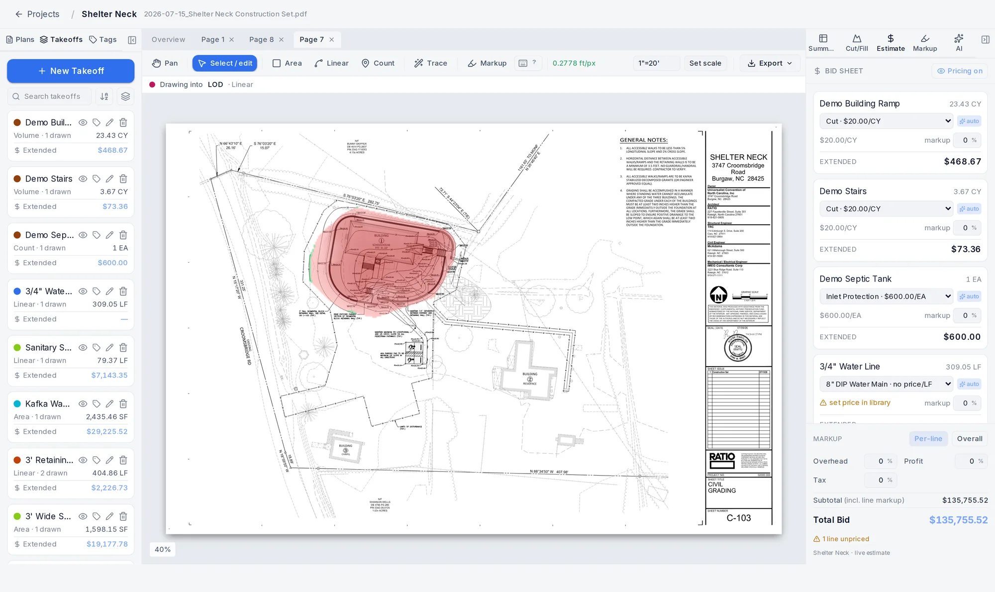
Costing & estimating
Turn the takeoff into a bid
Price your quantities off your own numbers, add your markup, and you have a bid without an afternoon in a spreadsheet. Cut and fill price as their own cubic-yard lines, so the earthwork is dead on.
- Build a Cost Library of your unit prices across nine site-work categories
- Price takeoffs straight from it with suggested prices you can override
- One bid sheet with per-line or overall markup, plus overhead, profit and tax
- Show or hide pricing, and hand over either a clean takeoff or a full priced bid
Bid-ready exports
Hand the GC something that looks the part
Put your logo and company info on it and send a clean takeoff summary, marked-up sheets with a color legend, or the numbers in Excel. Professional output that backs up your price.
- Branded takeoff summary PDF with your logo, address, phone and email
- Marked-up plan sheets with a color legend of that page's takeoffs
- Earthwork cut, fill, topsoil and subgrade sections itemized in the breakdown
- Export to Excel and CSV so the numbers stay numbers
Mark up the plans
Add text, arrows, highlight boxes, revision clouds and sticky notes right on the sheet. It is a separate layer, so it never touches your quantities, and you choose whether it shows on the export.
Run your jobs and your crew
Set a project status and bid date, assign it to someone, and sort by the bids you are chasing. Add your team by email so a crew can work the same jobs. Seats are $9.99/user per month or $99.99/user per year.
See it in action
Watch a full takeoff, start to finish
Upload a plan, set the scale, measure with auto-trace, run cut and fill, and price it. On a real job, in a few minutes.

Built by a contractor, for contractors
“I’m a Marine and I own a seven-figure site-work company. I built Werx Takeoff because I was tired of getting ripped off for takeoff software that was never built for the work we actually do. This is the tool I run my own company on. I bid my real jobs with it. If it didn’t work, I’d lose money. It works.”
Who it’s for
For the crews that move the dirt
Excavation, site work, grading and dirt contractors doing quantity takeoffs off site plans. If you bid earthwork, utilities and erosion control, it was built for your work, not adapted from a generic PDF tool.
This is the tool I run my own site-work company on. We bid Carolina EarthWerx jobs with it every week. Fast, accurate enough to put my name on the number, and built for the work instead of a generic PDF tool.
Pricing
Simple, honest pricing
One plan, everything included. Pay monthly or save with annual.
Monthly
Billed monthly. Cancel anytime.
Get started- Unlimited projects & plan sets
- Auto-trace + every measurement tool
- Cut / fill engine with the heat map
- Cost Library, bid sheet & branded exports
- Add your crew with team seats
Annual
Best valueSave 33% vs monthly.
Get started- Unlimited projects & plan sets
- Auto-trace + every measurement tool
- Cut / fill engine with the heat map
- Cost Library, bid sheet & branded exports
- Add your crew with team seats
Everything is included: auto-trace, the cut/fill engine and heat map, costing and bid sheet, and branded exports. Add your crew for $9.99/user per month or $99.99/user per year.
Why Werx Takeoff
Enterprise capability, without the enterprise baggage
The big estimating names are powerful, general-purpose platforms. Werx Takeoff does site-work takeoff, dirt and utilities first, for a simple monthly price with no annual lock-in.
- Purpose-built for site work: excavation, grading, utilities, concrete, paving and more
- $149.99/mo or $1,200/yr. No annual contract, no enterprise lock-in
- Auto-trace, a real cut/fill engine, and the machine-GPS heat map
- Cost Library, bid sheet and branded PDF, Excel and CSV exports
- Up and running in minutes, not a months-long rollout
Legacy & enterprise estimating suites
Bluebeam · STACK · Trimble · AGTEK
- Built for every trade, not focused on site work
- Enterprise sales, annual commitments and seat licensing
- Heavier to learn and set up than most site crews need
- Powerful, but you buy the whole platform to do a takeoff
Enterprise capability without the enterprise price tag or the annual lock-in.
Schedule a demo
Talk with the WerxOS team
See it on your own plans before you commit. The WerxOS team will set up a quick walkthrough.
Prefer to call? (252) 424-0654 · sales@werxos.com